Your Solution for Precise Reality Capture

Behind every scan is a team dedicated to doing what is right and doing it well, delivering quality you can trust-every project, every time. We invite you to experience the difference with us today!
For a free estimate or general inquiry, submit the form below.
Service Overview

Transforming Complex Data into Clear Deliverables

Discrepancies between record drawings and actual site conditions can result in costly change orders, project delays, and safety risks. At Nederveld, we use advanced 3D laser scanning, photogrammetry, and LiDAR technology to produce highly detailed construction as-builts, 2D CAD files, 3D BIM models, point clouds, and more. Whether you're starting a new build, renovating an existing facility, or preserving a historic site, our Reality Capture services provide the crucial deliverables your team needs.

At Nederveld, we’re always looking for passionate individuals who lead with initiative and uphold integrity in all they do. In return, we offer an environment focused on both personal and professional growth—built on a foundation of mutual respect and a commitment to excellence.

Applications

When would you need Reality Capture services?

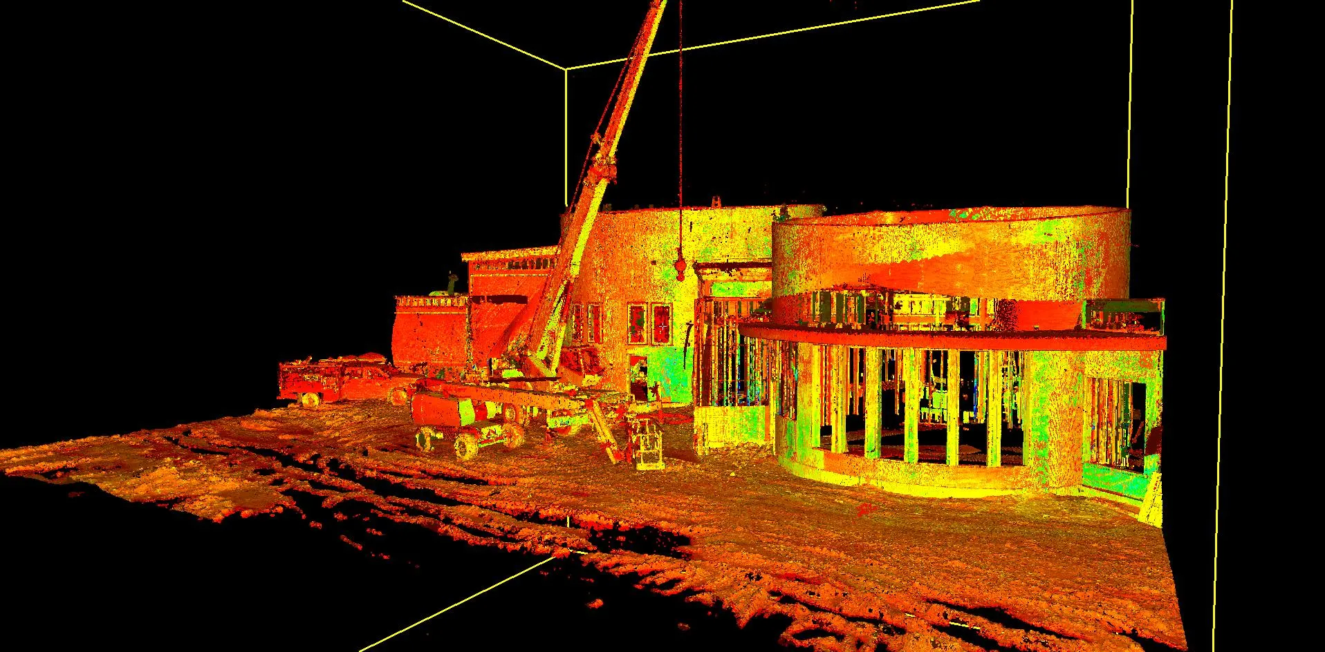
Reality Capture uses advanced technologies like 3D laser scanning, photogrammetry, and UAV mapping to accurately document existing conditions. By integrating precise survey control and industry experience, Nederveld transforms complex data into practical deliverables such as 2D CAD drawings, 3D BIM models, point clouds, and digital twins. This approach streamlines planning, improves coordination, reduces costs, and supports better decisions across a wide range of projects.

  • Existing building documentation and renovations
  • Engineering, architectural, and facility plans
  • Historic site documentation
  • Construction progress tracking
  • Improved coordination and reduced rework
  • Scan to BIM model creation
  • Design and planning integration
  • Material measurement (panels, stockpiles)
  • Faster turnaround from scan to deliverables

A workplace culture shaped by initiative, passion, and integrity.

Personal and professional growth built on mutual respect and trust.

A healthy work-life balance that helps us attract and retain the best.

Accuracy You Can Trust

Proven Technology and Processes

Accuracy is built into every step of our reality capture process. From field collection through final deliverables, our team applies rigorous standards to ensure dependable results that reduce risk and improve coordination.

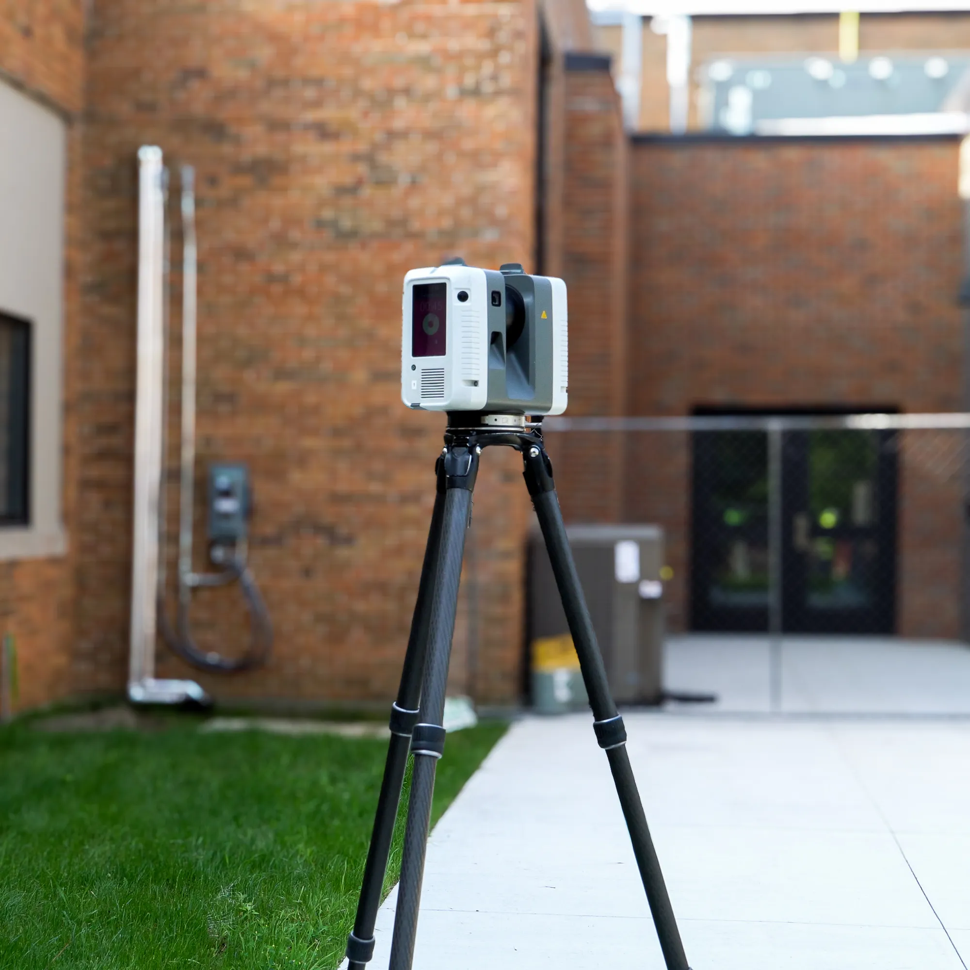
High-accuracy terrestrial laser scanning equipment

Survey control integrated into 3D scanning workflows

Processing aligned with industry best practices

At Nederveld, we’re always looking for passionate individuals who lead with initiative and uphold integrity in all they do. In return, we offer an environment focused on both personal and professional growth—built on a foundation of mutual respect and a commitment to excellence.

What we deliver

Accurate, Decision-Ready Reality Capture Data

Our Reality Capture services transform complex site conditions into clear, usable deliverables. By combining cutting-edge technology with integrity-driven service, we deliver results that consistently exceed expectations.

On-Site Scanning

  • High-resolution 3D laser scanning
  • Millions of points captured per second
  • Documentation of structure, geometry, and critical site features
  • Scanning before demolition, during framing, or post-installation for verification

Data Processing

  • Point clouds registered using industry-best software
  • Aligned to project coordinate systems or architectural datums
  • Clean, unified datasets ready for modeling, fabrication, or QA/QC

Modeling & Deliverables

  • 2D shop drawing underlays (DWG, DXF)
  • 3D surface or mesh models (RVT, STEP, IFC)
  • Deviation heatmaps
  • Edge-to-edge and anchor-to-anchor fabrication measurements

Our Expertise

Behind every successful scan is a process built on experience and trust. When it comes to Reality Capture, Nederveld delivers unmatched precision backed by extensive land surveying expertise and technical knowledge. Our deep roots in surveying allow us to integrate survey control into every 3D scanning project, ensuring accuracy, reliability, and confidence in your data. With nationwide service, fast response times, and personalized customer support, our custom solutions are equipped to meet your exact needs and provide clarity where it matters most. Our extensive team of dedicated professionals is here to support you every step of the way.
Since 1977, we have remained committed to serving others with respect and integrity, providing clear communication, reliable support, and a dependable experience from the first conversation through final delivery.
Get a Free Estimate Today!

About nederveld

It is our purpose to make people and places better.

History

Our History is an integral part of who we are and the level of service we provide.

Qualifications

Knowledge and, more importantly, understanding gleaned from years of education, training, experience, and industry expertise.